GPS and GIS combined to map activity levels
Published on 20 August, 2009
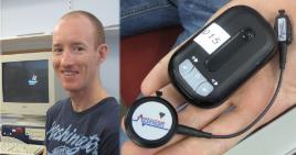
Health researchers monitoring activity levels are already using space-age tools such as GPS, GIS, accelerometers and heart monitors, usually attached to armbands or lanyards...
Future projects will be able to use much smaller integrated systems to combine the data sets in real-time. LINK here for a video interview

Dr Mitch Duncan and (inset) the activity monitors
That is according to CQUniversity's Dr Mitch Duncan, who is giving a free public talk on the use of GPS in physical activity research this week (1pm Thursday, August 13) at Rockhampton Campus (Building 33/Room G. 22).
Dr Duncan said that, rather than relying on people filling out surveys, the GPS monitors could show exactly where people have travelled over a given period.
Matched with GIS (Geographic Information Systems) maps, researchers could gauge whether people have encountered obstacles or disincentives to activity.
These obstacles could include traffic, a lack of footpaths, a lack of alternative pathways or poor lighting.
"Using this technology we can obtain very rich data about the actual activity pathways and levels of people," Dr Duncan said.

